Majuli Jorhat Bridge Over Brahmaputra: Construction, Length, Cost & Completion Date
The Majuli-Jorhat Bridge over the Brahmaputra River is one of the most important infrastructure projects in Northeast India. Built on National Highway 715K (NH-715K), the bridge is designed to create the first permanent, all-weather road link between Jorhat and Majuli, the world’s largest inhabited river island. The project is not only a transport corridor but also a critical lifeline for connectivity, safety, trade, healthcare, and cultural preservation.
Majuli has long depended on ferries for movement between the island and the mainland. During monsoon months, this dependence has often become dangerous and unreliable. The bridge is therefore seen as a long-term solution to isolation, river crossings, and emergency transport challenges.
Executive Summary
- Project name: Majuli-Jorhat Bridge
- Highway: NH-715K
- Total bridge length: 6.81 km
- Total corridor length: About 8.25 km including approaches and embankments
- Bridge type: Two-lane major bridge with paved shoulders
- Construction status: Remobilization and quality-control phase as of March 2026
- New contractor: SPS Construction India Pvt. Ltd.
- Expected completion: Late 2027
- Key concern: Floods, erosion, river navigation, and dolphin conservation
This bridge is being developed under the Ministry of Road Transport and Highways (MoRTH) and NHIDCL as part of a wider strategy to improve strategic and economic connectivity in Assam and the Northeast.
Why the Majuli-Jorhat Bridge Matters
Majuli is globally known for its cultural identity, natural beauty, and Neo-Vaishnavite heritage. It is also one of the most erosion-prone river islands in the world. Over time, Brahmaputra riverbank erosion has reduced the island’s landmass and disrupted the lives of the people living there.
The bridge is important because it aims to solve three major problems at once:
- Year-round transport connectivity
- Emergency access for medical and disaster response
- Economic integration for farming, trade, tourism, and handicrafts
Geopolitical and Historical Context of Majuli
Majuli has faced geographical isolation for generations. Before 1622 AD, the Brahmaputra reportedly flowed north of Majuli. Later shifts in the river’s course isolated the island and exposed it to severe erosion.
The 1950 earthquake in the Brahmaputra Valley made the erosion crisis worse. Landslides and huge sediment loads changed the river’s flow, raised the riverbed, and intensified bank collapse. As a result, Majuli’s size reportedly shrank from about 1,250 square kilometers in 1950 to around 500 square kilometers today.
The island is home to communities such as the Mishing, Deori, and Sonowal Kachari people, along with many residents connected to the Satras, the historic Vaishnavite monastic institutions.
Why ferry travel became a major concern
For decades, the island depended on ferries between Nimati Ghat in Jorhat and Kamalabari Ghat in Majuli. These services were often irregular, under-regulated, and risky during floods and strong currents.
- April 2012: A ferry disaster claimed 49 lives.
- September 2018: Another boat mishap near Guwahati led to a ₹630-crore modernization fund supported by the World Bank.
- September 8, 2021: Two passenger ferries collided off Neamatighat in Jorhat district, causing casualties and missing persons.
These incidents made clear that ferry dependence could not remain the long-term transport solution for Majuli.
People and places affected by erosion
River erosion has displaced families repeatedly. Residents such as Dipankar Dutta of Saraati village said his family lost homesteads to the Brahmaputra up to 11 times over two generations. Raghumani Das of Samaguri village described how ancestral land that was once 3.5 kilometers inland was eventually swallowed by the river.
This is why the bridge is widely seen as more than infrastructure. It is an existential necessity for the island’s survival, mobility, and safety.
Fluvial Geomorphology and Erosion Crisis
The Brahmaputra is one of the most dynamic and erosive rivers in the world. Its behavior is shaped by Himalayan topography, monsoon rainfall, and seismic activity. The river carries enormous amounts of sediment and changes course frequently.
At the Pandu monitoring station, sediment transport has been reported at around 2 million tons per day during the monsoon season. The river’s discharge in Assam typically ranges from 8,500 to 17,000 cubic meters per second, with peak flows rising even higher.
This creates a braided river system that shifts continuously and erodes banks on both sides. Majuli’s left bank has been especially affected, with bank-line shifts reported at:
- 1990–2000: -57.02 meters per year
- 2000–2010: -53.65 meters per year
- 2010–2020: -38.66 meters per year
These erosion trends have destroyed homes, farmland, and public assets. Conventional embankments and geo-bags have not been enough to stop the damage. In many places, embankments fail because of poor design and recurring floods.
Another concern is that new bridge piers can sometimes affect river flow and increase local scour. That is why the Majuli-Jorhat Bridge has been designed with a reduced pier footprint and long spans to minimize disruption to the river.
Project Timeline, Sanction, and Retendering
The project has gone through several phases of approval, delay, and restructuring. It is managed by MoRTH through NHIDCL and is part of the broader Bharatmala and highway connectivity framework.
Key administrative milestones
| Milestone Date | Project Event | Status / Financial Detail |
|---|---|---|
| November 17, 2020 | NH-715K declared | Regulatory foundation established |
| February 4, 2021 | Project sanctioned by MoRTH | ₹925.47 crore baseline budget |
| February 8, 2021 | Contract awarded to UPSBCL | Project officially initiated |
| July 9, 2021 | Physical construction began | Mobilization phase |
| September 2024 | UPSBCL withdrew from the site | 30.65% physical progress achieved |
| March 29, 2025 | Revised cost approved | ₹1,019.17 crore revised estimate |
| October 6, 2025 | LoA issued to SPS Construction India Pvt. Ltd. | ₹657.66 crore balance work contract |
| March–May 2026 | Active supervision tenders | Quality-control phase |
| Late 2027 | Projected completion | Operational readiness expected |
In mid-2024, problems became difficult to ignore. Parliamentary discussion, including a Zero Hour intervention by MP Shri Gaurav Gogoi, highlighted issues such as non-payment to local subcontractors, weak project management, and failure to handle the river’s difficult terrain.
After building only about 30.65% to 32% of the work, UPSBCL withdrew. In response, MoRTH imposed penalties, terminated the arrangement, and moved to re-tender the remaining work.
The revised financial estimate of ₹1,019.17 crore was approved on March 29, 2025. Later, on October 6, 2025, SPS Construction India Pvt. Ltd. received the Letter of Acceptance for the balance work at a bid value of ₹657.66 crore, excluding GST.
The company was required to submit a performance security of ₹32.88 crore within 30 days. The agreement also includes a three-year defect liability period after completion.
Bridge Design and Engineering Features
The Majuli-Jorhat Bridge has been planned to withstand strong currents, high sediment flow, and deep-water scour. The design also aims to reduce ecological disturbance and support continued navigation in the Brahmaputra.

Bridge specifications
| Specification | Value | Engineering Purpose |
|---|---|---|
| National Highway | NH-715K | Connects Jorhat and Majuli through the highway network |
| Total bridge length | 6.81 km | Spans the braided Brahmaputra channels |
| Total corridor length | About 8.25 km | Includes approaches and embankments |
| Number of spans | 40 | Distributes load and reduces river obstruction |
| Span length | 125 meters each | Minimizes pier count and scour risk |
| Vertical clearance | 10 meters above Highest Flood Level | Supports navigation on NW-2 |
| Road configuration | 2-lane bridge with paved shoulders | Supports freight and passenger movement |
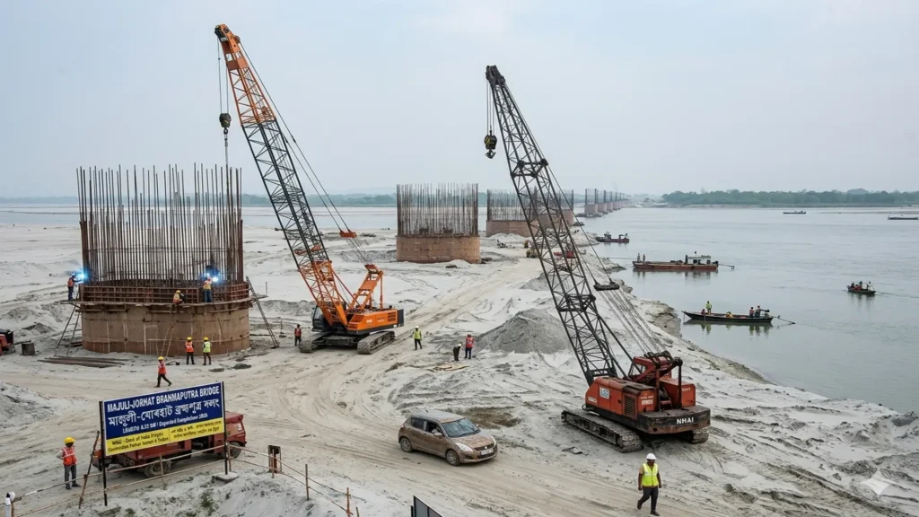
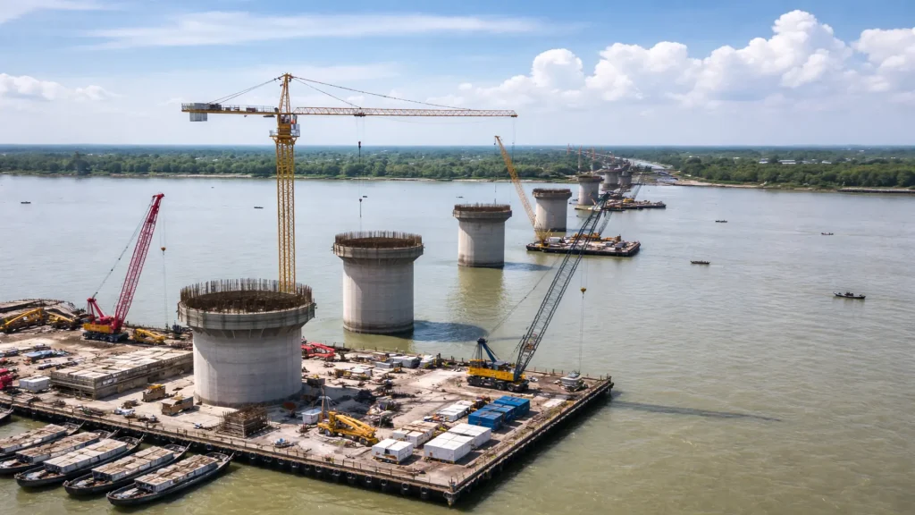
| Concrete technology | Barge-mounted boom pumps and batching plants | Allows construction in deep-water river conditions |
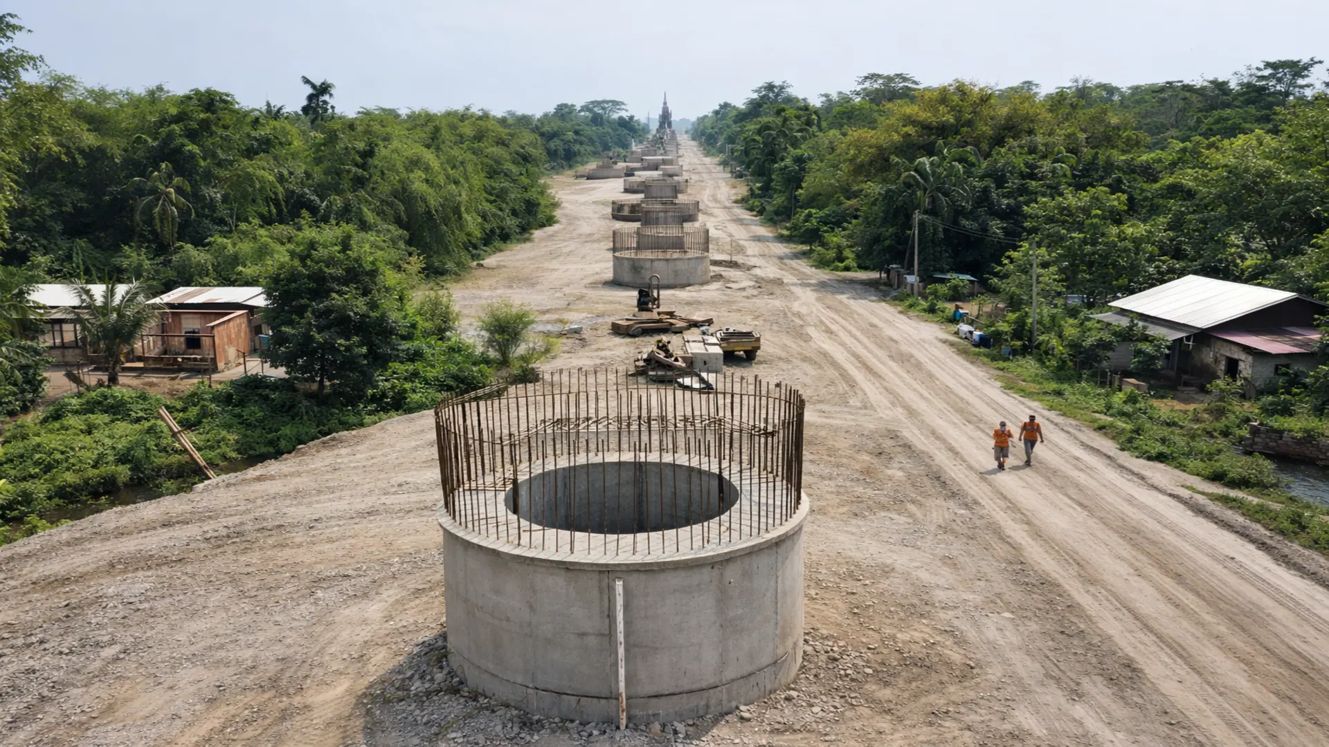
The bridge uses long spans to reduce the number of piers in the river. This is important because fewer piers reduce hydrodynamic disturbance and the risk of erosion around the foundations.
Construction in the middle of the river depends on advanced equipment such as floating batching plants, transit mixers, and barge-mounted pumps. These methods are necessary because normal land-based construction is not possible in many areas of the riverbed.
Environmental Management Plan and Dolphin Protection
The Brahmaputra basin is home to sensitive aquatic life, especially the endangered Gangetic river dolphin (Platanista gangetica). Bridge construction can create underwater noise, riverbed disturbance, and movement of heavy barges that may affect the species.
Why the Gangetic dolphin is important
The Gangetic dolphin is a key indicator of river health. It is already under pressure from pollution, fishing nets, habitat fragmentation, boat traffic, dams, and poaching.
Studies across the Ganga-Brahmaputra basin have shown that accidental deaths linked to dredging and boat collisions make up a major share of dolphin mortality.
Mitigation measures under the EMP
- Deployment of acoustic deterrent devices to keep dolphins away from construction zones
- Reduced or halted waterborne construction during dolphin foraging hours
- Dedicated rescue and rehabilitation support
- Scientific monitoring of flora and fauna in the project zone
- Awareness training for workers and contractors
- Compensation support for fishermen affected by damaged nets
The Environmental Management Plan identifies the dolphin’s active foraging windows as 07:00–10:00 hours and 15:00–17:00 hours. Construction-related movement in water is expected to be reduced during these periods.
The project budget also includes specific environmental allocations:
- ₹15.00 lakh for a power boat for rescue and rehabilitation
- ₹12.00 lakh for operation and maintenance of that boat
- ₹30.00 lakh for biodiversity monitoring
- ₹10.00 lakh for fisherman compensation
- ₹15.00 lakh for training and awareness programs
These measures are intended to balance infrastructure development with conservation responsibilities.
Socio-Economic Impact on Majuli
The bridge is expected to transform life on the island by improving mobility, trade, and access to services. It may also reduce migration by giving residents more reliable economic opportunities locally.
Benefits for agriculture and local trade
Majuli’s economy depends heavily on farming and handicrafts. The island produces rice, mustard, and traditional pottery, especially in areas such as Salmara and Dakshinpat.
With a direct road link to Jorhat, transport time may fall from unpredictable ferry waits to a 15–20 minute road journey. That can reduce spoilage, cut logistics costs, and improve profit margins for local farmers and artisans.
Tourism and cultural preservation
The bridge can also strengthen tourism. Majuli already attracts visitors for its Satras, Raas Leela celebrations, and river island landscape. Easier access may increase tourism flow from the mainland and support homestays, guides, transport services, and handicraft sales.
At the same time, easy access may create pressure on the island’s spiritual and cultural balance. The Satras have long maintained clear boundaries between religious life and political activity. The 103-year-old burha bhakat Padmashree Gopiram Borgayan of the Sri Sri Uttar Kamalabari Satra has emphasized that politicians may visit for blessings but should not turn the monastic space into a campaign site.
Health and disaster response
Perhaps the biggest social benefit is emergency access. During floods, ferry movement can stop completely. That creates serious risk for medical patients, pregnant women, and people needing urgent care.
The bridge will function as an all-weather corridor for:
- Emergency evacuation
- Disaster relief movement
- Medical transport to Jorhat
- Supply of essential goods during floods
Improved access to healthcare may also help reduce maternal and infant mortality over time.
The Satra Ecosystem and Cultural Heritage
Majuli is the center of Assamese Neo-Vaishnavite culture, spread by Srimanta Sankardeva and his disciple Madhavdev. The island currently has 22 active Satras, including prominent institutions such as Auniati, Dakhinpat, Kamalabari, and Garamur.
These institutions preserve sacred and cultural traditions such as:
- Sattriya dance
- Bhaona performances
- Paalnaam rituals
- Traditional mask-making
While the bridge will make access easier, it also makes cultural protection more important. A larger flow of visitors could commercialize or dilute the island’s spiritual environment if tourism is not managed carefully.
Majuli-Jorhat Bridge and the Wider Northeast Infrastructure Network
The bridge fits into a much larger infrastructure strategy under the Act East Policy, Bharatmala, and regional connectivity plans. The goal is to link the Northeast more efficiently with the rest of India and with Southeast Asia.
Majuli-Jorhat Bridge is part of a broader road and bridge network that includes several major projects across Assam.
Major related infrastructure projects
| Project Name | Location / Highway | Strategic Function | Status |
|---|---|---|---|
| Majuli-Jorhat Bridge | NH-715K, Assam | Connects Majuli to the mainland and supports emergency evacuation | Contract awarded to SPS Construction; late 2027 target |
| Dhubri-Phulbari Bridge | NH-127B, Assam/Meghalaya | India’s longest river bridge, improving trade corridors | Under construction; JICA funded |
| Bogibeel Bridge | Dibrugarh / Dhemaji | Rail-cum-road connection that improves logistics and defense movement | Operational since 2018 |
| Jogighopa Bridge | NH-17, Assam | Connects to the upcoming Multi-Modal Logistics Park | Ongoing EPC construction |
| Guwahati-North Guwahati Bridge | Urban Assam | Improves mobility and reduces congestion | Under construction by SPS Construction India Pvt. Ltd. |
| Majuli-Bongalmara Road | Balichapori to Lakhimpur | Strengthens northern connectivity through Luit and Subansiri bridges | Under ASRIP; ₹694.77 crore investment |
Collectively, these projects form an “Upper Assam Road Grid” that strengthens trade, mobility, and strategic logistics. They also support wider international connectivity initiatives such as the Kaladan Multi-Modal Transit Project and the India-Myanmar-Thailand Trilateral Highway.
The Majuli project also reflects cooperative federalism. The central government is funding the balance work, while the Government of Assam has supported land acquisition, utility shifting, forest clearances, and GST-related facilitation. Assam has also allocated ₹5.71 crore for local support work linked to the project.
Conclusion
The Majuli-Jorhat Bridge is much more than a construction project. It is a long-awaited intervention aimed at correcting the isolation of Majuli and improving the island’s resilience, economy, mobility, and safety.
Its successful completion by late 2027 depends on disciplined execution, strong supervision, and strict environmental compliance. It must also protect the Brahmaputra’s fragile ecosystem, especially the endangered Gangetic dolphin, while supporting the cultural life of the Satras and the livelihoods of local communities.
For Majuli, the bridge represents a shift from dependence on dangerous ferry routes to permanent, reliable, and future-ready connectivity. For Assam and the Northeast, it is a strategic node in a much larger infrastructure transformation.